Three weeks ago, the entire kitchen wall in our office was filled with maps of the world. Diversity and inclusion week was being celebrated. We were asked to highlight the place we were born, by pasting coloured stickers on the map. Australian continent is deemed down under, but we placed Australia at the centre of the world. I mean, the wall.
Last week at office, I noticed a new map of Australia on the same wall. A different one, with blurred border lines separating a huge number of “states” and “territories”, all highlighted with various colours, with new names. New, to me – a recent immigrant.
As a child, I loved colouring maps. I was fascinated by borders, routes and names.
“Where are the border lines?”
I always wondered how the boundaries of states and nations were made. I don’t remember much, but I would ask, who drew those lines and how. During trips to a temple in the adjacent south Indian state, I might have pestered my dad or an elder cousin, “Did we cross the border already?”, “Where is the line that i saw on the map?” I wonder if they might have pointed at the river and the mountain ranges as the bus entered the border town. I never understood.
Years later, the much grown up adult me would figure it out. Those borders on the map are not real. They are a socio-political construct. Nothing to do with geography.
“Routes that create territories”
In the past, the invaders and colonisers used maps to discover new territories. To then change the landscape, peoples, culture, everything. They say Map is not the territory. But those conquerors used maps to make new territory. Bruno Latour says, “The great man is a little man looking at a good map”.
We trust a map so much these days that we are lost without it. We take it literally, or almost fatally, as this German driver did (from a story I read in an old copy of Readers Digest).
The semi-conscious middle-aged man was being questioned at the hospital after his accident, “Why did you drive your car at high speed directly at the barricades. Didn’t you notice the exit was blocked for repair. That too, on a sunny day?” His reply, “I followed the GPS on my car”.
Names: old – new – old
The city I grew up – Coimbatore – is near the foothills of the beautiful hill station, Ooty. Its historical name is Uthagamandalam. The British made it their summer capital of the south. The name was a mouthful though. They tried pronouncing, but made a mess of it, naming Ootacamund. The locals might have resented it, even if they couldn’t have resisted that change. Eventually, it became Ooty.
Thirty years after the British left, the local government decided to change the name to its old Uthagamandalam. Still, a few locals resisted this change. But they might have figured:
If the names could be changed then,
the names could be changed now.
The new (old?) colourful Australian Map
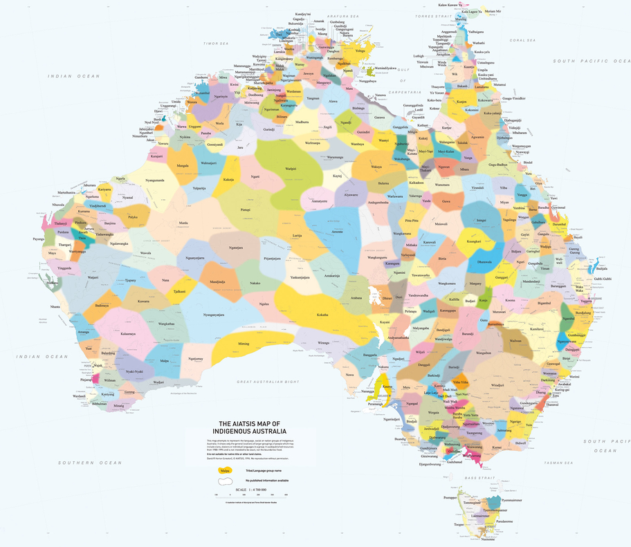
That map on the kitchen wall last week was to mark the National Reconciliation Week. The AIATSIS map is a “visual reminder of the richness and diversity of Aboriginal and Torres Strait Islander Australia. It was created in 1996 as part of the Encyclopaedia of Aboriginal Australia project and attempts to show language, social or nation groups”.
Maps, with its borders, routes and names, decide the way we see the world. They don’t just tell us where we are, they determine who we are.
Perhaps, we don’t stop with a new map on the old wall.
We bring the old map back to the new minds.
(This is from my speech delivered last week at our Toastmasters club on the theme of National Reconciliation Week in Australia, which is all about “relationships between the broader Australian community and Aboriginal and Torres Strait Islander peoples”. Please note, while I am still learning about this important topic, my attempt was to touch on the related topic of maps, through stories, anecdotes and insights.)

Leave a comment